Operational value of GIS and Remote Sensing in access constrained environments
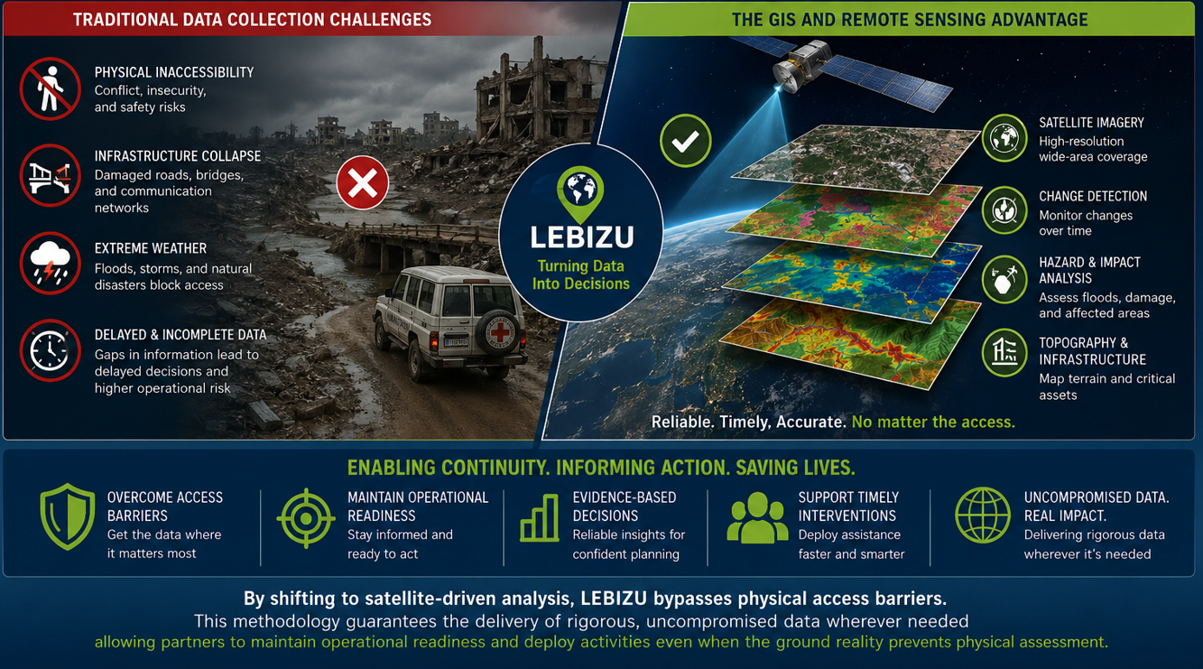
In today’s rapidly evolving environmental, development and humanitarian landscape, timely and reliable information is essential for effective decision-making. Yet, traditional field-based data collection methods often fail precisely where accurate information is needed most in areas affected by conflict, insecurity, infrastructure collapse, or extreme weather events.
Road blockages, damaged communication networks, security risks, and inaccessible terrain can significantly delay or entirely prevent physical assessments. These challenges create critical information gaps that affect operational planning, emergency response, resource allocation, and effectiveness of intervention.
The GIS and Remote Sensing Advantage
GIS and remote sensing technologies provide a transformative alternative to conventional data collection approaches. By leveraging satellite imagery, spatial analytics, and geospatial intelligence, organizations can monitor, assess, and analyze conditions remotely without requiring physical presence on the ground.
At LEBIZU, we utilize advanced geospatial technologies, high-resolution satellite imagery, cloud-based analytics, and modern spatial intelligence platforms to deliver accurate, timely, and evidence-based insights in even the most inaccessible environments. Through satellite-driven analysis, we overcome physical access barriers and ensure continuity of information flow during crises and operational disruptions.
This methodology guarantees the delivery of rigorous and uncompromised data wherever needed, allowing partners to maintain operational readiness, support timely decision-making, and deploy interventions even when on-the-ground assessments are not feasible.
LEBIZU’s Technical Capacity and Advanced Geospatial Platforms
LEBIZU combines strong technical expertise with advanced geospatial infrastructure to deliver high-quality spatial intelligence services across humanitarian, environmental, and development sectors.
Our multidisciplinary team possesses practical experience in:
- GIS and spatial analysis
- Remote sensing and satellite image processing
- Climate and environmental analytics
- Hazard and risk mapping
- Web GIS and interactive dashboard development
- Spatial database management
- Monitoring, evaluation, and geospatial reporting
- Drone and UAV data integration
- Decision-support system development
To ensure efficiency, accuracy, and scalability, LEBIZU utilizes advanced industry-standard platforms and technologies, including:
- ArcGIS ecosystem
- QGIS and open-source GIS solutions
- Google Earth Engine
- Cloud-based geospatial analytics platforms
- Real-time spatial dashboards
- AI-assisted image classification and change detection tools
- GPS and mobile data collection systems
- High-resolution commercial and open satellite imagery
Our technical workflows integrate data from multiple sources to provide comprehensive spatial intelligence products tailored to partner needs. This enables LEBIZU to deliver rapid assessments, dynamic monitoring systems, predictive analytics, and evidence-based planning tools that support both emergency response and long-term development programming.
Supporting humanitarian and development operations
GIS and remote sensing technologies play a critical role not only in humanitarian response but also in long-term development planning and resilience building.
Humanitarian applications
In emergency and crisis settings, geospatial technologies support:
- Rapid disaster impact assessments
- Emergency response coordination
- Population displacement monitoring
- Flood and drought early warning systems
- Damage and needs assessments
- Humanitarian logistics and access planning
- Conflict and risk monitoring
These capabilities enable humanitarian actors to respond faster, prioritize assistance effectively, and operate efficiently in highly dynamic environments.
Development applications
Beyond emergency response, GIS and remote sensing provide powerful tools for sustainable development planning, infrastructure management, environmental monitoring, and evidence-based policy support.
LEBIZU supports development partners through geospatial solutions that strengthen:
- Climate adaptation and resilience planning
- Integrated water resources management (IWRM)
- Agricultural monitoring
- Urban and regional planning
- Natural resource management
- Environmental and ecosystem monitoring
- Infrastructure and utility planning
- Land-use and land-cover analysis
- Renewable energy site suitability assessment
By providing spatial intelligence and long-term monitoring capabilities, GIS technologies help governments, NGOs, development agencies, and private sector partners make informed investments and improve the effectiveness of development interventions.
These capabilities provide organizations with the situational awareness necessary to act quickly, prioritize interventions, and maintain operational readiness even when field access is restricted.
Beyond accessibility: Saving time, resources, and operational effort
In addition to overcoming physical access barriers, GIS and remote sensing technologies provide significant operational efficiencies that help organizations save time, reduce costs, and optimize resource deployment.
Traditional field assessments often require extensive logistics, transportation, staffing, security arrangements, and long deployment timelines. In fragile or geographically challenging environments, these operations can become costly, risky, and time-consuming. Satellite-based analysis dramatically reduces these burdens by enabling rapid remote assessments without the need for large field teams.
Faster decision-making
GIS and remote sensing technologies enable near real-time monitoring and rapid information generation. Instead of waiting days or weeks for field reports, organizations can quickly access updated spatial information to support urgent operational decisions.
Faster access to information allows decision-makers to respond earlier, prioritize interventions efficiently, and minimize operational delays.
Reduced operational costs
Remote sensing significantly lowers the financial burden associated with repeated field missions. By minimizing travel, accommodation, transportation, fuel consumption, and security costs, organizations can allocate more resources directly toward program implementation and beneficiary support.
GIS driven planning also improves resource efficiency by helping organizations:
- Identify priority intervention areas
- Optimize logistics and supply routes
- Reduce duplication of efforts
- Improve targeting accuracy
- Allocate personnel and assets more effectively
Minimizing human effort and risk
Field operations in insecure or disaster-affected areas often expose personnel to safety and health risks. GIS and remote sensing technologies reduce unnecessary exposure by allowing analysts and decision-makers to conduct assessments remotely.
This approach minimizes:
- Physical travel requirements
- Repetitive manual surveys
- Time-intensive ground verification
- Exposure to conflict zones or hazardous environments
As a result, organizations can maintain operational continuity while protecting staff and improving overall efficiency.
Scalable and repeatable analysis
Unlike conventional assessments that are often limited in scale and frequency, satellite-driven analysis can cover large geographic areas consistently and repeatedly over time. This makes GIS and remote sensing highly effective for long-term monitoring, trend analysis, and evidence-based planning.
At LEBIZU, we integrate geospatial intelligence into operational workflows to help partners achieve faster, safer, and more cost-effective decision-making processes. By transforming spatial data into actionable insights, we enable organizations to maximize impact while reducing operational burdens.
Reliable data for sustainable impact
In access-constrained environments, delayed or incomplete information can lead to inefficient responses and increased operational risks. GIS and remote sensing technologies reduce these uncertainties by providing consistent, scalable, and objective data sources.
LEBIZU’s geospatial solutions support governments, humanitarian agencies, NGOs, development partners, and private sector actors by delivering actionable intelligence that improves coordination, planning, resilience, and operational effectiveness.
Our approach combines:
- Satellite imagery analysis
- GIS based spatial modeling
- Hazard and vulnerability mapping
- Change detection analysis
- Web-based mapping and dashboards
- Spatial decision-support systems
- Environmental and climate analytics
- Monitoring and evaluation support
Building resilient operations through geospatial Intelligence
As operational environments become increasingly complex, organizations require innovative tools that enable informed decision-making under uncertainty. GIS and remote sensing technologies are no longer optional enhancements they are critical operational assets.
By shifting toward satellite-driven analysis and geospatial intelligence, LEBIZU empowers partners to maintain continuity, strengthen resilience, improve development outcomes, and deploy interventions with confidence, regardless of physical access limitations.
Through reliable, timely, and uncompromised data, we help organizations transform information into action wherever it is needed most.